Hiking Rainy Lake and Maple Pass Loop Trail in North Cascades National Park, Washington

Maple Pass Loop Trail is one of the best hikes in North Cascades. This hiking guide will tell you all you need to know about the hike to Maple Pass Loop and Rainy Lake in Washington.
Often hailed as the best day hike in North Cascades, Heather – Maple Pass trail is a beautiful loop hike that traverses through different landscapes around Lake Ann. It is a difficult hike but if you are fit then you can literally drive over from Seattle and hike it as a day trip.
Heather – Maple Pass’s popularity is most likely due to the diverse view and terrain the entire hike so you will never be bored. You will also get a view of Ann Lake from all different angles on this hike since the hike loops around the lake. But that’s not it! On Maple Pass trail you can also see other lakes such as Rainy Lake from high above, as well as multiple peaks of the Cascades Range and maybe even a bear.
In addition, since Rainy Lake and Maple Pass Loop share the same parking lot and trailhead, you can do these two hikes together (we did Rainy Lake after we finished Maple Pass Loop) and it was a nice and relaxing walk.
And the reason why I call this trail Heather – Maple Pass is because you will technically be hiking on both Heather Pass and later on Maple Pass during this hike. In addition, the best view is actually on Heather Pass (so I always find the name Maple Pass Loop misleading!).
In this article, you will find all the practical information on the hike to Maple Pass Loop and Rainy Lake, when to get there, the best time to hike, what the actual hike is like as well as my personal tip to maximize your time if your goal is to get the best photo at Maple Pass Look trail.
This blog contains occasional affiliate links, where I receive a small commission on sales of the products/hotels that are linked at no additional cost to you. In addition, as an Amazon Associate, I earn from qualifying purchases.
How long and how hard is Maple Pass Loop Trail?
Maple Pass Trail is a relatively challenging hike that provides wonderful views of Lake Ann from the ledges surrounding the lake. This hike is dog friendly and can be done in either clockwise or counter-clockwise direction.
Here are some general statistics on Maple Pass Loop in North Cascades Washington. The stats below do not include the add-on portion to Rainy Lake or to Lake Ann itself.
Hike length: 7.5 miles loop trail
Time it takes: 4 – 5 hours
Elevation Gain: 2000 feet (some other website says 2100-2200 feet, but my watch only shows less than 2000 feet elevation gain)
Active Calories burned (based on Apple Watch): 1100 Active Calories
Difficulty level: Relatively difficult (can be steep and long, did not see any kids on the trail)
Dogs: Dogs on leash are allowed on the Maple Pass Loop Trail but not allowed over the pass and into North Cascades National Park.
Pass Needed: Northwest Forest Day Pass ($5)
Bathroom: At the trailhead; none at the top

Where is Maple Pass Loop Trail and Rainy Lake Trail? How Do I reach Maple Pass Trailhead?
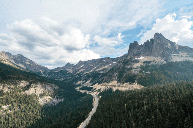
Heather – Maple Pass Loop and Rainy Lake share the same trailhead and parking lot. This is why I talk about them together even though they are technically different hikes. Maple Lake trailhead overlaps with Rainy Lake trailhead in the beginning, but they separate after about 0.5 miles.
Maple Pass Loop trailhead is along the SR-20 near North Cascades National Park in Washington State. The closest town to the trailhead is Winthrop followed by Twisp (unless you count Mazama as a town). You can type in Maple Pass trailhead on Google Maps and it will direct you right there.
Many people mistakenly think that Rainy Lake and Maple Pass Loop are in North Cascades but technically they are right outside of the national park in the Okanogan-Wenatchee National Forest (part of the hike actually borders North Cascades National Park).
It is easy to reach Rainy Lake and Maple Pass trail if you are in North Cascades National Park, as the Maple Pass Loop trailhead is located along SR 20 (N Cascades Hwy) as you drive through the park to the east.
You should always check SR 20/ N Cascades Hwy road status before driving to Rainy Lake/ Maple Pass to avoid disappointment. Here I list the best resources to check the North Cascades park status, road status and trail conditions.
- North Cascades Park Current Conditions here
- North Cascades NPS twitter with the most updated park condition and status
- North Cascades road condition here
- North Cascades trail conditions here
- North Cascades webcam feed from Visitor Center
There are occasional road closures during peak summer season due to wildfire and roadwork, so be sure to check before you attempt to hike Maple Pass Loop and Rainy Lake!

Is there parking at Maple Pass Loop Trail?
There is a small parking lot at Rainy Lake/ Maple Pass Loop trailhead that fits about 40-50 cars. We got there around 10:45am on Wednesday in August and took the last spot. Therefore if you are hiking in the summer or on the weekend, you should definitely aim to get the Maple Pass trailhead before 10am.
When the Rainy Lake/ Maple Pass trailhead parking lot is full, you can park right outside of the parking lot along the N Cascades Hwy. We saw a number of cars parked there when we left later in the afternoon.
You need to have a NW Forest Pass to hike Rainy Lake/ Maple Pass Loop trail. You can buy the pass ahead of time or pay $5 at the fee station (and deposit the cash) and leave the filled out pass on your car dash. Bring a pen and exact change with you.

When is the best time to hike Heather-Maple Loop Pass?
Early fall (September and October) and peak summer season (late July and August) are the best time to hike Maple Loop Pass, but for different reasons.
Fall (September and October) is the best time to hike Maple Loop Pass due to the golden color of the larch trees and cooler temperature. There is also less risk of wildfire (which would close down the N Cascades Hwy and the hikes) and before snow hits North Cascades which shuts down SR-20.
Summer (late July and August) is also a good time to hike Maple Loop Pass trail. Since Maple Loop Pass is above 6500 feet at the highest point, there can be snow on the trail even in July but the hike do-able then. Wild flowers on the trail peak in August, making the hike extra beautiful and gives you the iconic view of wild flowers and Lake Ann that you see online.
If you are planning to hike Rainy Lake/ Maple Loop Pass in the summer, definitely check park conditions and road conditions because there is an increasing amount of wildfire in the area. (We actually tried to do North Cascades the summer before but we had to change our plans last minute due to wild fire in North Cascades).
During winter North Cascades has snow and avalanche danger and SR 20 North Cascades Highway has a seasonal closure that usually starts mid November.
The North Cascades Highway closure usually happens between milepost 134 (Ross Dam Trailhead) and milepost 171 (Silver Star Gate). The North Cascades Highway (SR 20) usually reopens by early May. During the closure you won’t even be able to access the Rainy Lake/ Heather – Maple Pass trailhead.
Should I hike Maple Pass Trail in Counter Clockwise or Clockwise direction?
Whenever there is a loop hike, the question is always which direction do you go? So which direction should you hike Maple Pass trail?
The general recommendation is to hike Maple Pass Loop counter clockwise, where you will have a gradual ascend (partially in the woods), a view Lake Ann during the hike and a steep descend on switchbacks in the woods.
If you want to get the steep part out of the way first, then you can hike Maple Pass trail clockwise, finish the 4 mile steep uphill (mostly in the forest) first, then slowly and gradually descend on the other side of Lake Ann.
Either direction of the Maple Pass hike will provide you with great views so it really is a personal preference. We hiked Maple Pass Loop counter clockwise and I thought it was a good choice since the latter half really was pretty steep, which would’ve not been great for us on the way up.
Details of Maple Pass Loop Trail in North Cascades
Maple Pass Trailhead (Mile 0 – 1)
Once you are parked and has your Northwest Forest Pass in your car, it is time to start the hike to Maple Pass!
There is no where (that I saw) in the parking lot that says where Maple Pass Loop trailhead is. The only sign we saw were to Lake Trail and on the self-service pay station there is a sign pointing towards Rainy Lake. We got really confused but actually you just need to follow the sign to Rainy Lake or Lake Trail to find the Maple Pass trailhead. But technically you should follow the Lake Ann Trail up according to the national park official information.

There are two self-service pay stations in the parking lot, the actual trailhead starts behind the pay station that is closest to the highway.

The sign will point to Rainy Lake TR No.310 to the left and Maple Pass TR. No. 740 to the right. If you are hiking Maple Pass counter clockwise (the recommended direction), then follow the sign for Maple Pass TR. If you want to hike Maple Pass Loop clockwise (steep part first), then follow the sign to Rainy Lake.
If you follow the sign towards Rainy Lake, you will be walking on flat paved path for about half a mile before seeing another sign towards Maple Pass and go uphill into the forest.
If you follow the sign towards Maple Pass Trail, you will start going uphill immediately into the forest. The first 0.8 miles is pretty much just a gradual uphill on switchbacks in the woods. Enjoy this part of the hike as you hike in the shaded woods because this is pretty much the only shade you will get!

After 0.8 miles, the shaded trail will end and you come to an open meadow area with wildflowers lining up the trail (if it is during peak bloom). If it’s during fall you will see the golden colors of the larch trees. Continue climbing up this gradual dirt and rocky path.

Mile 1 – 2.5 (the best part of Maple Pass hike)
At around 1.2 mile you will see a sign towards Lake Ann, which is the actual lake you are hiking to see (but from above of course). If you want to take a detour and hike towards Lake Ann, you can follow the sign to go downhill towards the lake shore.
We decided against it since lakes in North Cascades generally look way nicer from above rather than from shoreline. Also we really did not want to hike down then have to hike all the way back up again!
If you decide to not do the side trail to Lake Ann, continue to follow the Maple Pass trail uphill up to Heather Pass.
At around 1.5 miles (took us 1 hour to get to 1.5 miles because we are pretty slow), you will get your first glimpse of Lake Ann! This part of the hike is pretty rocky but having that lake view makes the hike feel a lot better.


As you continue uphill on the trail, you will now have Lake Ann on your left (since the hike really is to circle around Lake Ann as you go higher and higher). At around the 2 mile mark the trail becomes more of a switchback in order to gain elevation. But during our hike in August there were a lot of wildflowers on the trail so it was pretty nice.

Around 2.3 miles on the trail you will see a sign for Heather Pass. Walk another 0.2 miles then you will start to have the amazing view of Lake Ann with the iconic mountain backdrop. This is also where I suggest you take photos (with the lake in the background).


The reason I suggest taking photos here is because this part of the trail is wide and you can stand here to take photos. As you hike more, there is actually no place for you to just stand there and take photos (if you want to be in the photo that is). I am really glad we took photos here because if we didn’t, I don’t know if I would be able to take a photo with the lake (and myself in it).
As you continue on the trail, there are 2 more switchbacks where you can see Lake Ann like this.

I believe the third switchback is where everyone takes the photo of Lake Ann with wildflowers (see photo below). This is around 2.5 miles into the hike if you hike Maple Pass in counter clockwise direction.

Tip: Be sure to take photos of Lake Ann when you see it from this angle. If you miss this opportunity that’s it, no more!
Before I hiked Maple Pass Loop, I always thought this photo was taken at the “summit”, where I can just sit somewhere, relax, eat lunch and enjoy this view with the wildflowers right in front of me. But no, that is not the case on this Heather-Maple Pass Loop hike!
Mile 2.5 – 3.5 (Steeper uphill to the highest point)
If you just want to see this view, you should turn back and go back the way you came.
Wait, why are you suggesting we turn back? Isn’t this trail a loop?
Maple Pass is a loop trail, and since the entire loop is about 7.5 miles long, you still have 5 miles to go to complete the loop. If you want to see what is there on the rest of the Maple Pass hike, then go ahead and finish the loop. But if you want to save your energy and maximize rewards, then you should turn back at this point.
We did not turn back because we thought if we continued to climb higher, we would have an even better view of Lake Ann. Also I was really curious what other things we could see on the Maple Pass trail so we continued on.
After seeing the lake, I thought we were able to see more so we continued to follow the trail to climb up more. We actually saw a bear during this part of the hike which was interesting (the bear was far away so it was no threat to us). This part of the climb was quite barren and hot and it was getting a bit more steep.

After about another half mile, we finally made it up to the top of the mountain, and we quickly realized there was no more view of Lake Ann (WHAT!) You can see all the surrounding peaks, but at this point even at the edge you wouldn’t really be able to see Lake Ann anymore.
The cool thing is that you are now pretty much adjacent to North Cascades National Park (I hope you realized by now that you are not technically in North Cascades)!


When I say top, I am only talking about the immediate ledge (Maple Pass). You actually have to walk up a steeper hill after this. So at this point you are about 3 miles into the 7.5 mile hike, the picture below shows the path you will need to go to reach the highest point of the Maple Pass Loop trail.
From here to the highest point is about another half mile, although the view at the highest point is actually pretty cool!

Although you don’t get to see Lake Ann on this part of the trail, you do see all the peaks in the Cascades Range which is pretty nice. To get to the highest point of the hike was also a much steeper climb than what we had done previously. So right before the big hill, we found a rock to sit on and had some lunch.
The last 4 miles (steep downhill)

Once you hit the highest point on this hike, you can now see “the other side” of the ledge. I have to say this view is actually really nice even though it is not the same view you expected I bet.
From the photo you can see the trail going steep downhill and yes that’s where you will be walking. Officially from this point on you will be hiking downhill for the next 4 miles!
When you are at this point in the hike, the trail downhill is on your right hand side (if you are facing the view). There was some confusion when we were hiking as it seemed like there was also a trail on the left but no, it is on the right.
The first mile or so of the downhill is out in the open and it is not super steep. As you walk downhill you actually get the last glimpse of Lake Ann on your left hand side. Then soon you will also see Rainy Lake (on your right side).


After seeing Rainy Lake you will enter the forest and start descending the rest of the 3 miles steep downhill on switchbacks.
As we were hiking down the seemingly endless switchbacks, I was pretty glad we decided to hike Maple Pass Loop in the counter clockwise direction. I think I would’ve been pretty miserable hiking up 4 miles of steep switchbacks and open field without much view to look at.
Once you are back down from Maple Pass, you will hit Rainy Lake trail (the paved portion of the trail). If you plan to go to Rainy Lake, turn right when you see the paved trail and follow it for another 0.5 miles.

What is Rainy Lake? Is Rainy Lake Worth it?
Rainy Lake is actually a larger lake than Lake Ann and it is accessible to everyone. The trail to Rainy Lake is completely flat and paved, and we saw someone in a wheel chair on this trail towards Rainy Lake.
Rainy Lake is a nice and relaxing stop after a long hike of Maple Pass Loop. If you want to be able to dip your toe (or straight up swim) in the lake after a long and sweaty hike, this is the perfect stop. We also saw someone floating in an inflatable while fishing on the lake, which looked extremely relaxing.

What to bring to hike Maple Pass Loop and Rainy Lake?
Since Maple Pass Loop is a long hike, you want to make sure you are adequately prepared.
Water and snack/ packed lunch: I brought 3L of water and I think it was about sufficient. However we were lucky that we hiked on a pretty cloudy day. Since half of the trail has no shade, if it’s a hot sunny day, you might consider bringing more than 3L of water. We did not see that many water source on the trail, so keep that in mind if you are just planning to bring a lifestraw filter or something.
Sunscreen/ Sunglasses/ hat: since the Maple Pass hike has minimal shade, be sure to have sun protection to avoid getting a sunburn.
Camera: even an iPhone would be good. But if you love taking photos with an actual camera, I highly advice you to bring a wide angle lens. For this hike I used both a regular zoom lens and the Sony wide angle lens but I think the wide angle was more useful to capture landscape.
Hiking Shoes: I generally always wear hiking shoes when I hike and this trail has some rocky parts so I highly recommend wearing hiking shoes to stay comfortable.
Hiking Poles: The steep downhill during the second half of the hike was pretty brutal on my knees. I think having hike poles definitely helped with that. We actually rented hiking poles from REI since we did not want to pay for checked in luggage!
Bug Spray: There were some bugs when I hiked Maple Pass but it wasn’t super bad. I did read that there could be a lot of mosquitos depending on the time of the year and the day. It’s never a bad idea to be prepared.
Swim Suit: if you are planning to swim in Rainy Lake, be sure to bring your bathing suit and a towel!
Bear Mace: We bought bear mace from REI before coming to North Cascades and we did see a bear on the trail. However this trail is pretty popular so generally bear would run away if they see people. I would say have the bear mace with you just in case.
Where to stay near Maple Pass Loop?
Camping or staying in a town near the east side of North Cascades are the best options if you want to minimize driving to the Maple Pass trailhead in the morning.
North Cascades Camping
If you want to be close to Maple Pass trailhead and also save money, then camping in North Cascades is the best option for you. You can get to Maple Pass Loop trailhead early in the morning without having to drive hours to get here (it took us 2 hours to drive to the trailhead from Burlington).
North Cascades National Park has 10 campground sites and day use facilities. You can make reservation for all sites in campgrounds along SR 20 during operational seasons (through mid September).
Colonial Creek Campground and Gorge Lake Campground are the closest campground to Maple Pass Trailhead/ Rainy Lake.
Towns near Maple Pass Loop
If you do not want to camp (I did not want to), then the best town to stay in is Winthrop.
Seeing Winthrop is like stepping into an American Old West movie. The entire town is modeled after the Old West with its building design and decorations. I had no idea Winthrop would be so cute (if I had known I would have booked more nights there instead of Burlington).
Winthrop is only about an hour drive to Maple Pass Loop trailhead/ Rainy Lake and there are decent restaurants, cafes and shops in town as well. We had dinner at Carlos1800 Mexican Grill and Cantina, which was really good!

There are a number of well reviewed hotels in Winthrop that I would recommend. We personally stayed at Methow River Lodge. The room was big and spacious and the bed was comfortable. We had an entirely contact free check in process (they texted me the password to unlock the door about an hour before check in). However if you do not have cellular service then that might be a problem (the town itself has signal).
Other popular places to stay in Winthrop include Mt. Gardner Inn, River’s Edge Resort and Hotel Rio Vista.
Other North Cascades Resources
If you are planning a trip to North Cascades, I have a few other blogs you might be interested in.
- Hiking Blue Lake Trail
- Cascade Pass/ Sahale Arm hiking guide
- Day trip to North Cascades
- Best day hikes in North Cascades National Park
Like this post? Pin this Maple Pass Hiking Guide to Pinterest!
