Lake O’Hara Hike to Lake Oesa via Yukness Ledges in Yoho National Park

Yukness Ledges alpine route to Lake Oesa is one of the most spectacular hikes in Yoho National Park. This hiking guide will show you everything you need to know to hike the Yukness Ledges alpine route.
Lake O’Hara in Yoho National Park has some of the best hiking trails in all of Canadian Rockies.
One of the most spectacular (and not too difficult) hike at Lake O’Hara in Yoho National Park is the West Opabin trail to Lake Oesa trail via the Yukness Ledges alpine route.
Most people only have time and energy to either walk around Lake O’Hara or hike to Prospect Point, the famous Lake O’Hara view point. But few have the opportunity to combine Lake O’Hara and Lake Oesa via Yukness Ledges.
This Lake O’Hara hiking guide will go in detail on all you need to know to hike from Lake O’Hara to Lake Oesa via Yukness Ledges and step by step direction to hike this beautiful trail.
This blog contains occasional affiliate links, where I receive a small commission on sales of the products/hotels that are linked at no additional cost to you. In addition, as an Amazon Associate, I earn from qualifying purchases.

Where is Lake O’Hara?
Lake O’Hara is located in Yoho National Park in British Columbia. It is part of the Canadian Rocky Mountains and also part of a larger protected area known as the Canadian Rocky Mountain Parks World Heritage Site.
Other national parks that you may know that are in Canadian Rockies include Banff National Park and Jasper National Park in Alberta.
Lake O’Hara is known for its stunning beauty, pristine condition, rare ecosystem, and incredible hiking opportunities.

How do I get to Lake O’Hara?
Unlike the popular Lake Louise and Moraine Lake, Lake O’Hara is generally not accessible to most of the general public.
There is only one access road to Lake O’Hara from the parking lot and only Parks Canada bus can drive on the access road. The access road from the parking lot to Lake O’Hara is 11km one way.
Parks Canada operates a few daily buses at 8:30am and 10:30am from mid June to early October every summer.
In 2024, Lake O’Hara buses operate from June 21 to October 6.
How to Get the Lake O’Hara bus ticket?
The buses to Lake O’Hara are operated by Parks Canada. Only very limited number of people are lucky enough to get the bus ticket.
Day Use Bus Ticket
Lake O’Hara day use bus ticket is extremely difficult to get. There is generally a lottery in the spring every year where you pay to enter a random draw.
Once the winners are announced at the end of the month (usually the lottery draw application is at the beginning of the month), winners have about one month to commit and pay for the bus ticket.
Any unclaimed bus tickets will be open to the public again a month after where you can queue up early morning and try to get these limited leftover tickets. This is exactly how we were able to get the Lake O’Hara bus ticket.

In 2023, due to the changes to the reservation system, there will not be a lottery for Lake O’Hara bus ticket.
Instead ticket reservation will open online beginning 8am Mountain Time on April 12, 2023.
You will need to make a new profile, go to the reservation website beginning at 7:30am MT. At 8am you will be randomly assigned a place in the queue and get tickets. If you arrive after 8am MT, you definitely will not get a ticket. See more details here.
The Lake O’Hara bus ticket will return to a random lottery in 2024.

Camping Reservation at Lake O’Hara
Another way to get a bus ticket to Lake O’Hara is through camping reservation.
Using the same website as above, you will need to make an overnight camping reservation for the summer season.
Camping reservation beings at 8am MT on March 28, 2023.
To avoid people booking up camp sites just for day use, you must have a tent with you to board the bus. See more details here.
Elizabeth Parker Hut camping Reservation at Lake O’Hara
Separate from the Parks Canada camping reservation above, the Alpine Club of Canada has camping options available at Elizabeth Parker Hut.
If you don’t mind dormitory style accommodation, see details on the official website on how to book.
Stay at Lake O’Hara Lodge

The most expensive way to get a bus ticket to Lake O’Hara is to get reservation at Lake O’Hara Lodge, which costs over USD 800 a night.
Unfortunately the lodge gets booked up one year in advance so if you really want to stay there during summer you will need to try to book at least one year in advance.
Note that if you do not get Lake O’Hara bus ticket, you cannot ride a bike or scooter on the access road.
Can I hike at Lake O’Hara if I don’t get a bus ticket?
If you cannot get the Lake O’Hara bus ticket, your only other option to access Lake O’Hara is to walk 11km one way on the access road.
The walk is easy with minimal incline but it is extremely long and boring. There is absolutely no view on the road and you will most likely encounter a bear (according to our bus driver).
If you do decide to walk 11km to Lake O’Hara, make sure you bring plenty of water, sunscreen and bear spray to stay safe. It’s best to start early so you have enough time to hike around Lake O’Hara.
You can always take the bus back after you finish hiking at Lake O’Hara. You do not need a reservation to take the bus back out.
The bus runs at 9:30am, 11:30am, 2:30pm, 4:30pm and 6:30pm. People with bus reservation get priority on the outbound bus, but when we visited there were multiple outbound buses at one time slot so you generally don’t have to worry about not being able to catch one on the way out.
What months should I visit Lake O’Hara?
If you want to hike and enjoy Lake O’Hara, then you must visit in the summer between early July and September.
There may still be snow on the hiking trails mid June even though the bus starts running then.
During July to September, the lakes are thawed and there is less snow (no snow at all in August) when you hike. You can explore the alpine meadows and see wildflowers during this time. Weather is usually warm and sunny (although you could expect thunderstorms and rainy days occasionally).
Late September and early October are also a great time to visit Lake O’Hara, as the fall colors create a stunning landscape of golden aspens and red larches. The weather is usually mild and stable during this time, making it a great time for hiking and exploring. But remember the bus stops running early October.
How to best hike around Lake O’Hara?
There are many hiking trails around Lake O’Hara, the most popular trail being the Opabin Plateau Circuit.
If you want to hike to see the Lake O’Hara viewpoint, then you will need to hike via West Opabin trail to Prospect Point. This is the postcard perfect shot that everyone comes to Lake O’Hara for.
However rather than hiking down East Opabin to complete the Opabin Plateau Circuit, you can actually hike to Lake Oesa via the Yukness Ledges Alpine Route, which is what I will go over in detail in this hiking guide.
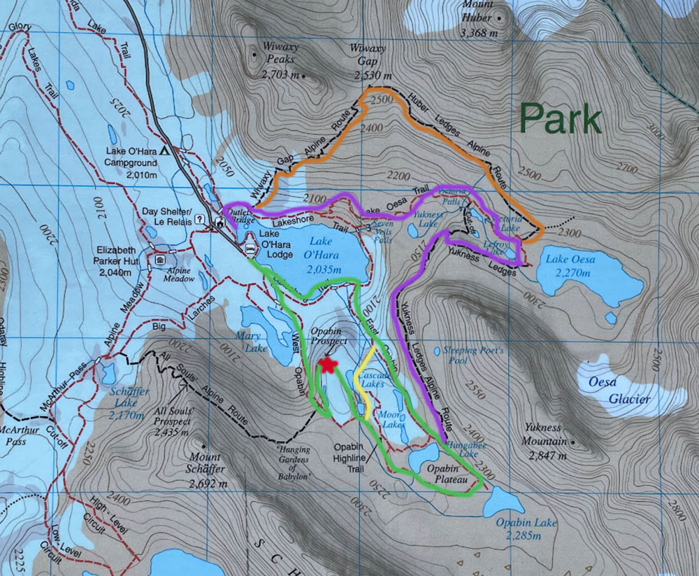
In summary, here are some of the most popular hikes at Lake O’Hara:
- Lakeshore Trail (easy, 2.8km/ 1.7mile loop around the lake)
- Opabin Plateau Circuit (moderate, 5.9km/ 3.7mile loop) – the green trail (the yellow part is the short cut between West Opabin and East Opabin trail)
- Lake Oesa Trail (moderate, 6.4km/ 4 mile round trip) – part of the purple trail
- McArthur Pass & Lake McArthur Trails (moderate/hard, 8km/ 5 mile round trip)
- Alpine Route: Yukness Ledges (Lake O’Hara to Lake Oesa) <– green + purple trail. This is what we will focus on in this post
- Alpine Route: Wiwaxy Gap/ Hubert Ledges – the orange Trail
- Alpine Route: All Soul’s Prospect
There are more hikes around Lake O’Hara. You can see the full list on the official website.
In this post, we will be focused on the Yukness Ledge Alpine Route from Lake O’Hara to Lake Oesa (you can also do the reverse from Lake Oesa to Lake O’Hara). This trail alone would pretty much knock off Lakeshore Trail, Lake Oesa Trail, and West Opabin Trail from the Opabin Plateau Circuit.
I think this hiking route is the best day hike at Lake O’Hara since you can see so much in one go!
How Hard is the Hike from Lake O’Hara to Lake Oesa via Yukness Ledges?
Length of Yukness Ledges Alpine Route: 5.6 miles (9km) loop.
Time: 4 hours
Elevation Gain: 1500ft
Difficulty: Moderate in terms of elevation gain; difficult because of rocky terrain and length
The Yukness Ledges Alpine route connecting Lake O’Hara to Lake Oesa is a moderate hiking trail that let you enjoy a little bit of everything: alpine lakes, cascading waterfalls, beautiful wildflower meadows, rapid moving streams, view of mountain peaks, and an alpine ledge.
You can do the Yukness Ledge Alpine Route in either direction. Many people go from Lake Oesa to Lake O’Hara in the clockwise fashion. We did Lake O’Hara to Lake Oesa in the counter clock wise direction because we wanted to see the Lake O’Hara viewpoint first.
I personally think going from Lake O’Hara to Lake Oesa was a good choice because we had a fantastic view of the lakes while hiking on the actual Yukness Ledge (if you go the other way around the lakes will be behind you).
In addition there were a lot of scrambling up from Lake O’Hara to Lake Oesa direction. I think scrambling down would be way harder.
Despite the”alpine route” name, I did not think Yukness Ledge was that hard or scary.
When I was doing my research, every internet source I came across said Yukness Ledge was an alpine route so only experienced hikers should attempt it. I read that the trail was super exposed and scary. I really hesitated and seriously did not want to hike this even though I wanted to see Lake Oesa.
In fact I was so scared I was thinking about hiking back down West Opabin Trail back to Lake O’Hara, walk around Lake O’Hara and then hike Lake Oesa separately.
Good thing I asked the ranger (and another hiker) about it and they both said it really is not bad or difficult.
So yes, Yukness Ledges is not hard and it’s not scary. If you have some basic level of fitness and it is a nice day (the ground is not wet), then I would highly recommend it. I would not do it if the ground is wet or slippery or covered in snow though because you need to scramble up for 20 minutes.
Detail Step by Step Hiking Guide from Lake O’Hara to Lake Oesa via Yukness Ledges Alpine Route
There are actually 3 different hiking routes involved in the Yukness Ledges Alpine Route:
- West Opabin Trail
- Yukness Ledge Alpine Route
- Lake Oesa Trail
I will write about these parts separately below. In addition, I will break out the West Opabin Trail into two parts, the first part is how to get to Opabin Prospect for the view of Lake O’Hara, then what to do after that.
Part 1. Lake O’Hara to Opabin Prospect via West Opabin Trail
The first part of this Lake O’Hara hike is to hike to Opabin Prospect via West Opabin Trail.
I will not elaborate too much on this part because I have a very detailed post on how to get from Lake O’Hara to Opabin Prospect.
Essentially from the Day Shelter (or Lake O’Hara Lodge), you will walk along Lake O’Hara towards Mary Lake (Lake O’Hara will be on your left hand side).

The trail can get pretty rocky as you hike up to Opabin Plateau but you will have a nice view of Mary Lake as you hike.

After about an hour you will see the sign for Opabin Prospect, which is the best viewpoint of Lake O’Hara and Mary Lake and what most people come here for.

Part 2. Prospect Point to Opabin Lake
After spending some time admiring the view of Lake O’Hara and Lake Mary from Prospect Point, it is time to continue to hike to Opabin Lake.
You will head back down from Prospect Point to the West Opabin Trail to continue this hike.

Once you are back on the main West Opabin Trail, continue on the narrow trail until you see wild flowers, open meadow with mountains in the backdrop.
You will also cross a wooden boarded bridge and a stream. Right next to the wooden bridge there is another sign with many different path.

Follow the sign to “Lake O’Hara via East Opabin“. This is the only arrow that points to the right (the Opabin Plateau Circuits” option has the arrows pointing to both direction so that’s not very helpful.
This part of the trail gets a bit confusing as more signs pop up pointing to all sorts of directions. We thought we were following the correct path to Yukness Ledges but we actually ended up at Opabin Lake by accident.
Ultimately if you want to go to Opabin Lake, follow the sign to Opabin Lake.

Assuming you want to see Opabin Lake, follow the (green) trail towards Opabin Lake as you walk on the open meadow, you will eventually see a couple of different small lakes, they are Cascade Lakes, Moor Lakes and Hungabee Lakes.

As you walk pass the two lakes, you will eventually need to go up a short but steep rocky trail and go to Opabin Lake.

You don’t have to go all the way to Opabin Lake to hike Yukness Ledges. In fact the Yukness Ledges trail starts before you have to hike this steep part to Opabin Lake.
The only reason we went to Opabin Lake is because we totally missed the sign to Yukness Ledges (despite trying to follow signs religiously).
Hiking to Opabin Lake and back to where Yukness Ledges is probably added an additional 20-30 minutes.
Part 3. Yukness Ledges
The route to Yukness Ledges may not be super obvious at first glance (considering we totally missed it and had to turn back). But it essentially is on a pile of rocks on the way to Opabin Lake.

If you see a lot of rocks like this, look out for the trail sign. The sign pointed towards Yukness Ledges but I think we mis-interpreted the sign.
All the alpine routes at Lake O’Hara have this special blue trail marker on it. Even in the photo above, you can see the little blue trail marker on the rock below the sign. You will need to look for that blue trail marker as you scramble your way up Yukness Ledges.

I guess the most difficult part of Yukness Ledges is the rock scrambling, which I actually find fun. This is where I am glad I didn’t have hiking poles with me since they would be a pain to maneuver while trying to scramble up a pile of rocks.
The scrambling lasts about 30 minutes (20 if you are super fast, but I am very slow). This reminds me of all the hikes in New York so nothing new there. But if you are from the west coast this may be a surprise for you.

If you look behind you now, you will see the Hungabee Lake behind you.
After 30 minutes, you will finally be on leveled ground on the Yukness Ledges! The ledge is small and narrow but it is not scary. The left side of the trail is completely exposed but it is not a sheer drop so don’t worry too much.

Soon you will be too distracted by the view to even remember this is a narrow ledge.
As you continue to walk forward, you now will have a different perspective of Lake O’Hara. This is the reason why I think hiking from Lake O’Hara to Lake Oesa is prettier because you are greeted with this view most of the way!
You will continue this nice and easy (pretty flat) walk for a while before you eventually have to turn the corner as the trail wraps around Yukness Mountain, leaving Lake O’Hara behind you.
The flat and easy part of the trail is now officially over, leaving you with more rocky path on an uphill battle.

As you hike this part, there is actually a very small alpine lake you can see, which I believe is called Yukness Lake.

As you continue on this rocky path, you will soon see a sign. The sign has two different routes you can take to Lake Oesa, one is towards Lake Oesa and another one is “Lake Oesa via Victoria Lake”.

I think both ways work but we went on the right side and ended up having to scramble a little bit again.
This part of the hike was pretty confusing and we had to rely on the blue trail marker to find our way. I don’t really think you can get lost since you can actually see the lake coming up but all the rocks are pretty annoying.

After you climb up these big rocks, it is actually flat on top. You will see Lefroy Lake on your left side as you walk towards Lake Oesa.

It looks close but it’s still kinda far away unfortunately. Continue on the rocky path and after another steep climb on rocks you will finally have arrived at Lake Oesa.


We were the only people here at Lake Oesa so we spent about 30 minutes eating our snack (we honestly did not have much snack as we forgot our food, sunscreen and bug spray at the hotel). But it was nice to just relax here after a long walk on rocky paths.
Part 4. Lake Oesa back to Lake O’Hara Lakeshore
The trail from Lake Oesa back to Lake O’Hara was not as nice as we had hoped. We actually thought it was going to be a walk in the park but we were in for a big surprise.
After resting at Lake Oesa, we struggled to find the way back. The trail sign was anything but useful and we eventually had to rely on the blue trail markers again to find our way.

But just looking at the hiking map, I think the direction towards Wiwaxy Gap/ Lake O’Hara made the most sense and you certainly don’t want to go back on the Opabin Plateau trail.
We were greeted with some stone steps going downhill from Lake Oesa. The path soon becomes a narrow dirt path which we welcomed since we were just very tired of walking on rocks and stone steps at this point.


As you continue hiking down, you will pass a couple of lakes, first Lefroy Lake then Victoria Lake.

To be honest there were a lot of hiking down rocky steps going down from Lake Oesa and it was not the best experience. Maybe because we were pretty tired at this point but it really felt we were walking on rocks endlessly.
Good thing we were accompanied by a nice waterfall (Victoria Falls) on the way down, which was actually pretty cool.

Right after the waterfalls you can expect some big rocky steps which requires some scrambling down. Not too bad, but not the best either (I must prefer scrambling up instead of down).
After the scrambling down, there were some more rocky steps and wide talus.


This part of the hike is still above the tree line so it’s rather hot and exposed. You will hike next to the final lake on this trail, Yukness Lake (you saw this when you were on the Yukness Ledges remember?)

This part of the trail actually felt pretty long and just……rocks, big rocks, small rocks, rocky steps, all sorts of rocks…Actually this part lasted about 20-30 minutes of walking on rocks.
Soon Lake O’Hara will come to view and you know you are this close to finishing even though at that time we still felt we were pretty high up above the lake.

But as you continue you will finally go through the forest, you will descend a number of switchbacks and ultimately a steep downhill on the eastern side of Lake O’Hara.

We were extremely happy to finally be back at Lake O’Hara and could walk at a leisurely pace.

We had about half an hour to spare before the outbound bus came. At that time there were a lot more people waiting for the bus at the Day Shelter (I did not see any of them while hiking).
Is Yukness Ledges Alpine Route worth it?
Yukness Ledges is totally worth it, the view was absolutely incredible and Yukness Ledges itself was not difficult, just some scrambling involved.
However if you want my honest opinion I have to say the worst part of the hike was Lake Oesa back to Lake O’Hara. The trail was mostly rocky and steep and there wasn’t too much to see.
I am extremely grateful we decided to hike Yukness Ledges between Lake O’Hara and Lake Oesa instead of going back down West Opabin Trial then do Lake Oesa as a round trip hike. That would totally not be worth it since Lake Oesa by itself was not that amazing.
But combining with Lake O’Hara and Yukness Ledge the entire alpine route was worth the effort on a nice and clear day.
Would I do it again? Probably not. I would however be interested in hiking to Lake McArthur if I ever get an opportunity to visit Lake O’Hara again.
What to bring to hike Yukness Ledges Alpine Route?
Since Yukness Ledges is quite a long route, when hiking Yukness Ledges you should bring appropriate clothings and gears as well as water and food.
Bear Spray: You definitely should bring bear spray if you are walking 11km to the Lake O’Hara trail head. There are a lot of bears in Yoho National Park and you have a very good chance of running into one if you are walking up the service road. Our bus driver told us that there is always one or two bears that hangs around there and we actually saw one from the bus while driving up. You can purchase bear spray online or at the Banff visitor center or a local REI store.
Water and Food: Although the day shelter at Lake O’Hara sells some drinks (not water) and snack, you should always be prepared to have food with you as you hike at least 14-15km that day if you are not taking the bus to Lake O’Hara.
Cash: If you are planning to buy snack or coffee or soda at the Day Shelter, you have to have Canadian dollars with you.
Bug Spray: Since you are hiking near lakes and in the woods, there are always bugs flying around. We forgot our bug spray and had to desperately borrow from someone after an hour at Prospect Point since nobody was around for the longest time.
Sun Protection: There is no shade on the service road if you are walking to Lake O’Hara trailhead. Even if you take the bus, when you hike on Yukness Ledge and Lake Oesa, there is minimal shade, so be sure to bring sunscreen and hat with you.
Hiking Shoes: Since the trail between Lake O’Hara and Lake Oesa is extremely rocky, hiking shoes are definitely something you should consider.
I did not use hiking poles for this hike but I can see how it would have been helpful during the Lake Oesa to Lake O’Hara portion since there were so much walking downhill on rocky steps.
Other than that I did not think hiking poles would have been useful on this hike (especially not during the scrambling part).
Like this post? Pin this Yukness Ledges Hiking Guide to Pinterest!
